Research Progress: Impact of Tropical Cyclone Development on the Instability of South Asian High and the Summer Monsoon Onset over Bay of Bengal
This study analyses the evolution of the South Asian High (SAH) during and after the development of tropical cyclone Neoguri over the South China Sea (SCS) in mid-April 2008, the formation of tropical storm Nargis over the Bay of Bengal (BOB) in late April, and an earlier Asian summer monsoon onset, as well as their interrelationships. It is demonstrated that strong latent heating related with tropical cyclone activities over the SCS can enhance the development of the SAH aloft and generate zonal asymmetric potential vorticity (PV) forcing, with positive vorticity advection to its east and negative advection to its west. Following the decay of the tropical cyclone, this asymmetric forcing leads to instability development of the SAH, presenting as a slowly westward-propagating Rossby wave accompanied by a westward shift of the high PV advection. A strong upper tropospheric divergence on the southwest of the SAH also shifts westward, while positive PV eddies are shed from the high PV advection and eventually arrives in the southern BOB. Such synoptic patterns provide favorable pumping conditions for local cyclonic vorticity to develop. The latent heating release from the cyclogenesis further intensifies the upper-layer divergence, and the lower and upper circulations become phase locked, leading to the explosive development of the tropical cyclone over the southern BOB. Consequently, a tropical storm is generated and the BOB summer monsoon commences. The study has been published in Climatic Change, the lead author is Prof. Wu Guoxiong at LASG, and coauthors are Dr. Ren Suling at National Satellite Meteorological Center, China Meteorological Administration, Dr. Xu Jianmin at National Satellite Meteorological Center, China Meteorological Administration, Dr. Wang Dongxiao at . State Key Laboratory of Tropical Oceanography, South China Sea Institute of Oceanology, Chinese Academic of Sciences, Dr. Bao Qing at LASG, Postdoctor Student Liu Boqi and Dr. Liu Yimin at LASG.
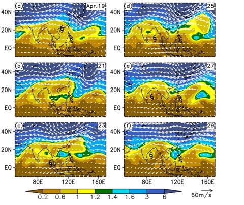
Figure: Wind (vector, unit is m s-1) and potential vorticity (shading, unit is PVU=10-6 m2 s-1 K kg-1) at the 360-K isentropic surface during 19 - 29 April 2008, after the occurrence of Typhoon Neoguri. “![[@D}W3MKV0]}(M7QC)`74]5](./W020200407596613549548.jpg) ” indicates the location of the tropical cyclone.
” indicates the location of the tropical cyclone.
More information at:
http://link.springer.com/article/10.1007%2Fs00382-013-1766-0