IAP Scientists Identified Key Circulation Features of Northeast China Cold Vortex and Their Association with Wave-breaking Process
Date:2015-04-01
Meiyu, transliterated from "the plum rain" in Chinese, got its Chinese name because the raining season prevails when the plums are ripe in southern and central China during June and July. The high humidity in the air during this season encourages the formation of mold and rot not only on food but on fabrics and walls as well. This period is generally avoided for tourism, but some sights are considered particularly poetic in the rain and fog.
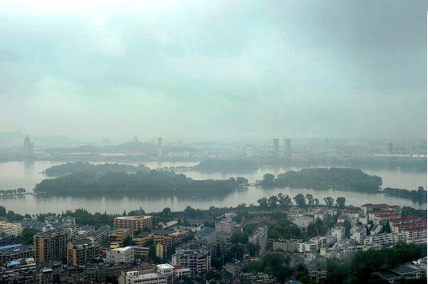
Fig. 1 The photo of Meiyu weather in Nanjing, Jiangsu (www.xinhuanet.com)
People in the southern and central China, Japan and Korea are very familiar with Meiyu, but little do they know that the Meiyu rainfall in East Asia is significantly affected by the abnormal frequency of Northeast China cold vortex (NCCV).
NCCV circulation is an important part of cut-off lows in the Northern Hemisphere. The NCCVs occur all the year and are particularly frequent during the late spring and early summer. The abnormal recurrence of NCCVs can bring floods and persistent cold weather to Northeast China, which results in a considerable reduction of local crop production. For example, severe floods over the Songhua River and Nenjiang River attacked Northeast China were induced by the NCCVs during summers in 1991 and 1998.
Recently, Dr. Xie Zuowei and Prof. Bueh Cholaw, from International Center for Climate and Environment Sciences, Institute of Atmospheric Physics, systematically investigated the NCCV circulations during May to mid-June. They identified distinct features of NCCV circulations and their associations with different blocking-type circulations over Eurasia continent.
Notably, their study proposed that cyclonic and anticyclonic synoptic wave breaking processes are favorable for the maintenance of NCCV circulations of different types and can trigger the persistent meteorological disaster events. Meanwhile, the study also reported the important weather impacts of NCCV circulations over other places, such as southern and central China.
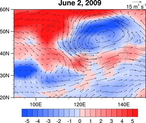
Fig. 2 Horizontal wind on 315 K isentropic surface (arrow, see scale at the right top) and air temperature anomalies at sigma level 995 relative to climatological daily mean over the years 1981-2010 (shading, see scale bar at bottom) associated with NCCV on June 2, 2009.
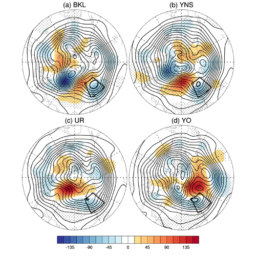
Fig. 3 Composite Z500 (contours; m) and associated anomalies (shading; see scales at bottom) at the peak days of (a) 21 BKL-, (b) 18 YNS-, (c) 19 UR-, and (d) 14 YO-NCCV events (from Xie and Bueh 2015). The contour interval is 40 m, and the thick solid contours (at 5570 m, 5500 m, 5540 m, and 5500 m) denote NCCVs. Dotted regions are statistically significant at the >90% confidence level. The polygon designates the region of Northeast China and the lowest point in each panel is drawn at (90°E, 20°N)
The findings could provide the basis for the medium-rage forecast of the disaster weather events that induced by NCCV circulations and the meaningful clue for the circulation forecasts of the first rainy season in South China and the Meiyu rainfall.
Reference: Zuowei Xie and Cholaw Bueh, 2015: Different Types of Cold Vortex Circulations over Northeast China and Their Weather Impacts. Mon. Wea. Rev., 143, 845–863. doi: http://dx.doi.org/10.1175/MWR-D-14-00192.1
Contact: Dr. XIE Zuowei, xiezuowei@mail.iap.ac.cn