IAP Scientists Reveal the Summer Monsoon Break over the Western North Pacific
Date:2018-04-23
During the monsoon season, rainfall is abundant in the mass but frequently exhibits obvious subseasonal oscillations, manifested by the alternation of the active and break spells. The drastic change of precipitation affects greatly social and economic activities by inducing extreme weathers such as flood and drought. The break for the South Asian and South China Sea summer monsoons has been well known, but the break of the western North Pacific (WNP) summer monsoon (WNPSM).has not been documented.
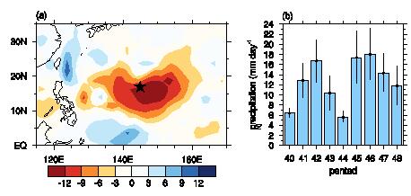
Recently, Dr. XU Ke and Prof. LU Riyu from the Institute of Atmospheric Physics (IAP) of the Chinese Academy of Sciences identified a distinct break phenomenon during the WNPSM (Xu and Lu 2015). This monsoon break occurs climatologically in early August over the ocean to the east of the Mariana Islands(10°–20°N, 140–160°E), accompanied with drastic rainfall reduction, convection suppression and weakening of monsoon trough. For about 30% of years, the monsoon break is particularly prominent, with the rainfall amount reducing by more than 10 mm day?1, being even less than that before the monsoon onset (Fig. 1). The remarkable changes of convection and circulation during the monsoon break not only modulate the local tropical cyclone (TC) activity, but also influence the TCs in a remote location, i.e., a region to the southeast of Japan (Xu and Lu 2016).

Fig. 1. (a) Difference of precipitation (mm day?1) between the break period (pentad 44) and the adjacent periods (pentads 42?43 and pentads 45–46) for the prominent break years. The star indicates the Mariana Islands. (b) Time series of the pentad mean precipitation (mm day?1, bars) averaged over the key region of monsoon break (10–20°N, 140°–160°E). Vertical lines on the bars indicate a ±0.5 standard deviation of precipitation at each pentad.
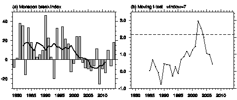
Results of a latest published study (Xu and Lu 2018) indicate that the break of WNPSM undergoes a significant decadal change around 2002/03 (Fig. 2). For the period 2003–2011, the monsoon break delays to mid-August, lagging behind the break for 1979–2002 by 5–10 days. This decadal change is attributable to the remarkable SST warming in the southern extent of the warm pool during mid- and late July, which results in a reversed meridional SST gradient in comparison with the 1979–2002 period and impacts evolution of convection over the WNP, finally leads to delayed occurrence of monsoon break.

Fig. 2. (a) Time series of the original (bars) and 7-year running mean (thick line) monsoon break index (W m?2). (b) Moving t values for the changes in the monsoon break index between the preceding and subsequent 7 years. The dashed straight line represents the 95% confidence level.
The series of studies have been published in Journal of Climate.
Reference:
Xu, K., and R. Lu, 2018: Decadal change of the western North Pacific summer monsoon break around 2002/03. J. Climate, 31, 177–193.
Xu, K., and R. Lu, 2016: Change in tropical cyclone activity during the break of the western North Pacific summer monsoon in early August. J. Climate, 29, 2457–2469.
Xu, K., and R. Lu, 2015: Break of the western North Pacific summer monsoon in early August. J. Climate, 28, 3420–3434.
Contact: LIN Zheng, jennylin@mail.iap.ac.cn
