Interannual variation of precipitation over the Hengduan Mountains
Date:2018-07-23
The Hengduan Mountains (HMs), with an area of 500000 square kilometers, are located in the southeast of the Tibetan Plateau (TP), with the YunGui plateau and Bayan Har Mountains to their south and north sides, respectively. HMs have the world’s largest elevation drop from about 4800 meters at the TP to about 600 meters at the Sichuan basin. Besides, Mountains and rivers exist alternately there, making the stereo-physiognomy with high mountains and deep valleys. Several major rivers in Asia originate from this region, and precipitation variation there is important to both local and remote areas. Therefore, it is meaningful to investigate precipitation variability over HMs.

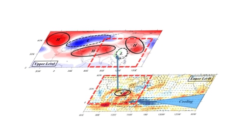
Schematic diagrams illustrating the processes of CEP cooling (bottom panel) and SRP (top panel) influence on the precipitation over HMs during rainy season.
The present study found that precipitation over the HMs during rainy has strong interannual variation, and it is influenced by the combined effect of central and eastern Pacific (CEP) SST anomalies and Silk Road pattern (SRP). These two factors reflect the different aspects of circulation anomalies. The CEP cooling plays a dominant role in influencing the anomalous lower level South China Sea cyclone, which helps moisture convergence over HMs, and the SRP is mainly related to the anomalous ascending motions there.
Reference:
Dong, D., G. Huang*, W. Tao, R. Wu, K. Hu, and C. Li, 2018: Interannual variation of precipitation over the Hengduan Mountains during rainy season. International Journal of Climatology, 38, 2112-2125. https://rmets.onlinelibrary.wiley.com/doi/abs/10.1002/joc.5321
