Strong convective weather, including thunderstorms, severe winds, hail, tornados, and short-term heavy rainfall, is a type of weather phenomenon that is extremely difficult to predict owing to its small spatial scales and short-term durations. In recent years, high-resolution numerical models have become the focus for weather forecasters to predict strong convective weather. They output simulated radar reflectivities and many other physical parameters that directly display the locations of strong convective weather for forecasters. However, these models have errors, which greatly limit their accuracy in convective weather forecasting.
In a paper recently published in Atmospheric and Oceanic Science Letters, Dr. LI Na and her coauthors from the Key Laboratory of Cloud-Precipitation Physics and Severe Storms (LACS) at the institute of Atmospheric Physics, Chinese Academy of Sciences, introduce an analogy-based method in strong convection forecasts using numerical model output.

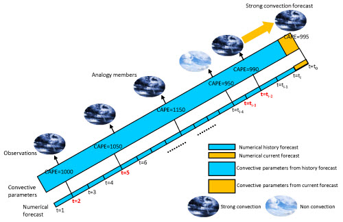
Diagram of an analogy forecast of strong convection. (Image by LI Na)
"The method is very interesting. It assumes that the occurrence of the atmospheric environment for similar weather phenomena is also similar in the model. So, using historical model forecasts, we can estimate the occurrence environment for current convective weather. It calculates many diagnostic parameters as predictors to detect the favorable-occurrence environment of strong convections. Historical forecasts that are most similar to current forecasts are identified by searching a large historical numerical dataset. The observed strong convective situations corresponding to those most similar times are then used to form strong convection forecasts for the current time," explains LI. An application of this method as a postprocess of the NCEP Global Forecast System (GFS) model shows that the method performs well in predicting the potential for strong convection in different regions of China.
"At present, the method only forecasts whether or not strong convective weather will happen. The specific phenomena of the weather, such as thunderstorms, surface strong winds, hail, and short-term heavy rainfall, are not considered. In future work, we hope to provide more specific forecasts regarding the kind of strong convective weather that will happen by improving the analogy metric and the corresponding observations," says LI.
Citation
Na LI, Lingkun RAN & Baofeng JIAO (2020) An analogy-based method for strong convection forecasts in China using GFS forecast data, Atmospheric and Oceanic Science Letters, 13(2), 97-106, DOI: 10.1080/16742834.2020.1717329. https://www.tandfonline.com/doi/full/10.1080/16742834.2020.1717329
Media contact: Ms. LIN Zheng, jennylin@mail.iap.ac.cn
