As a key parameter of the sea water, salinity plays a vital role in regulating ocean density, stratification, and circulation; also, it indicates the coupling between ocean, atmosphere, and land through water cycle. Gridded ocean datasets with complete global ocean coverage are of great importance to marine and climate research. Currently, owing to the sparsity of in situ observations, most of the ocean salinity gridded products are with 1° × 1° horizonal resolution, which is difficult to meet the requirements of small-scale Marine information research. A high-resolution gridded dataset is crucial for understanding ocean processes at various temporospatial scales.
A recent study published in
Earth System Science Data on 18 November 2022 presents a high-resolution (0.25° × 0.25°) ocean subsurface (1–2000 m) salinity dataset for the period 1993–2018 using a machine-learning method called feed-forward neural network. The study merges in situ salinity profile observations with high-resolution (0.25° × 0.25°) satellite remote sensing altimetry absolute dynamic topography (ADT), sea surface temperature (SST), sea surface wind (SSW) field data, and a coarse resolution (1° × 1°) gridded salinity product.
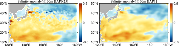
"IAP1° gridded salinity dataset was formally released in 2020. Two years later, we developed the new 0.25° × 0.25° reconstruction dataset, or what we call IAP0.25°. The new dataset shows more realistic spatial signals in the regions with strong mesoscale variations, e.g., the Gulf Stream, Kuroshio, and Antarctic Circumpolar Current regions, than the available IAP 1° × 1° resolution product." said Prof. CHENG Lijing, the corresponding author of the study. "This indicates the efficiency of the machine learning approach in bringing satellite observations together with in situ observations."
Figure. A comparison of salinity reconstruction at 100m for IAP 0.25° (left) and IAP 1° (right) at January 2016.
According to the study, the large-scale salinity patterns from IAP0.25° are consistent with the IAP1° gridded salinity field, suggesting the persistence of the large-scale signals in the high-resolution reconstruction. The SHAP method is also used to evaluate the effects of different inputs on the reconstruction of IAP0.25°.
The first author of the paper is TIAN Tian, a PhD candidate jointly supervised by the National University of Defense Technology and the Institute of Atmospheric Physics of the Chinese Academy of Sciences. The co-authors include Dr. WANG Gongjie, Dr. John Abraham, PhD candidate WEI Wangxu, Professor REN Shihe, Professor ZHU Jiang, Professor SONG Junqiang and Associate Professor LENG Hongze.
The new IAP0.25° dataset is available at http://doi.org/10.57760/sciencedb.o00122.00001, http://www.ocean.iap.ac.cn/ftp/cheng/IAP_v0_Ocean_Salinity_0p25_FFNN_0_2000m/, or http://www.ocean.iap.ac.cn/ .
This study was supported by the Strategic Priority Research Program of the Chinese Academy of Sciences [grant number XDB42040402], the National Natural Science Foundation of China [grant numbers 42122046 and 42076202], and Youth Innovation Promotion Association, CAS [grant number 2020-077].
Reference:
Tian Tian, L. Cheng*, G. Wang, J. Abraham, S. Ren, J. Zhu, J. Song, and H. Leng, 2022: Reconstructing ocean subsurface salinity at high resolution using a machine learning approach. Earth Syst. Sci. Data., 14, 5037–5060. https://doi.org/10.5194/essd-14-5037-2022.
Media contact: Ms.