New Weather Model Captures Every Angle of Mountain Winds for Sharper Forecasts
Date:2025-11-18
Imagine trying to predict the wind as it flows over a landscape. It's easy over a flat plain, but becomes incredibly difficult over a jagged mountain range. The wind doesn't just go over the peaks; it gets deflected, slowed down, and forced into gravity waves.
For computer models that predict our weather, this "drag effect" from complex terrain is a major source of error. Traditional models use a simplified "eight-direction" map of the mountains (8X scheme, like a compass with only North, Northeast, East, etc.). When the wind shifts to a direction in-between these points, the model's representation of the terrain "jumps," causing errors that ripple through the entire forecast. This is one of the reasons why weather predictions can be less reliable in mountainous regions.
To fix this, a team of scientists from the Institute of Atmospheric Physics at the Chinese Academy of Sciences, has developed and implemented a new, more advanced method.
“Think of it as upgrading from a basic compass to a precision instrument that can pinpoint any azimuth for mountain terrain.” Said Dr. Tian Yuhang, the lead author of the study. He and his colleagues at the State Key Laboratory of Earth System Numerical Modeling and Application developed an "All Flow Directions" (AFD) scheme. This allows the weather model to calculate the shape and steepness of the mountains continuously for any wind direction. This eliminates the "jump" and provides a much more realistic picture of how the wind interacts with the ground.
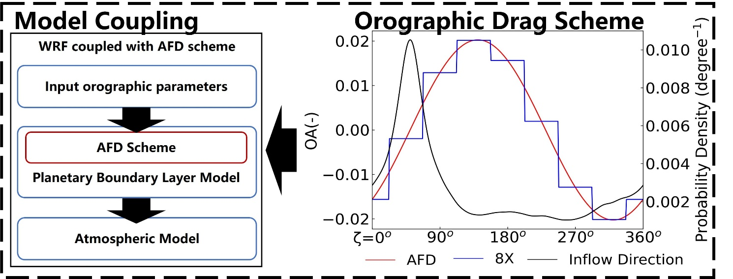
A schematic diagram of the coupling of the orographic drag scheme considering anisotropy within the WRF model framework. (Image by Tian Yuhang)
By testing their new model over the challenging terrain of the Qinghai-Tibetan Plateau, the team found significant improvements. The new AFD scheme led to a 10-20% increase in accuracy for simulating stratospheric wind patterns, which are crucial for determining large-scale weather systems.
“In simple terms,” said Prof. Xie Zhenghui, the corresponding author of the study, “by mapping the mountains more realistically, the model can better simulate how winds are slowed down and redirected as they flow over them. This creates a more accurate starting point for predicting various meteorological phenomena, such as cross-mountain airflow and mountain precipitation.”
The research, published in the Journal of Geophysical Research: Atmospheres, is a key step toward more reliable weather forecasts and climate projections for mountainous areas. It provides new technical support for predicting severe weather, managing water resources, and understanding regional climate change in some of the world's most complex and sensitive environments.
Paper information:
Tian, Y., Xie, Z., Xie, J., Jia, B., Qin, P., Li, R., et al. (2025). Implementation of the newly developed orographic drag scheme in the weather research and forecast model. Journal of Geophysical Research: Atmospheres, 130, e2025JD044517. https://doi.org/10.1029/2025JD044517