A heavy rainfall occurred on 21-22 July 2012 where the major rain belt extended from Southwest China to North China and was centered in Beijing. In this study, we discussed this extreme event from a climate perspective. During the past 60 years, North China has undergone a drying tendency, so flooding events are not common in North China in recent decades. The occurrence of the 2012 flood in the context of a multidecadal drying tendency has received great attention. In this study, we analyze the 2012 North China flood in the context of summer monsoon changes in the past 62 years (1951–2012). We examine whether climate change may have played a role in either the 2012 extreme rainfall or the recent multidecadal trend of decreased precipitation in North China. The study has been published in Bulletin of American Meterological Society, the lead author is Dr. Tianjun Zhou at LASG and coauthors are Ph.D students Fengfei Song, Renping Chen, Xiaolong Chen at LASG and Dr Chen Xianyan at National Climate Center.
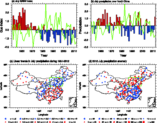
Although the damage caused by the 2012 floods in North China was large, the amount of precipitation was not unprecedented in the past 62 years. The flood occurred in the background of a longer-term drying tendency. Since the late 1970s, the total summer rainfall amounts have significantly decreased, but the rainfall intensity of single events has increased in North China associated with the weakening tendency of the EASM circulation partly due to the phase transition of the PDO. We are unable to confirm or reject the role of climate change in the 21–22 July 2012 rainfall event due to the inability of the CMIP5 models to accurately replicate observations in this region of China. The CMIP5 models show an increasing trend from 1950 to 2000, in contrast to the decreasing trend observed during this period. Both the mean and extreme precipitation in North China are projected to increase in the future, but the creditability of the projection is limited by the weakness of models to simulate the climatology of EASM and the design of CMIP5 projection experiments, which were not initialized with contemporary ocean observations and would not be able to reproduce the observed phase transition of the PDO.

Figure: (a) Normalized July EASM index derived from NCEP/NCAR reanalysis based on Guo (1983). The green line indicates the Pacific Decadal Oscillation (PDO) index derived from the website: http://jisao.washington.edu/pdo/PDO.latest; (b) Normalized July precipitation amount averaged over North China (35°N-43°N, 110°E-122°E, 23 stations are included). The green line indicates the Pacific Decadal Oscillation (PDO) derived from the website: http://jisao.washington.edu/pdo/PDO.latest; (c) Linear trends of July precipitation during 1951-2011 (units: mm year-1), the green box indicates the north China region (35°N-43°N, 110°E-122°E); (d) Anomalies of July precipitation in 2012 relative to 1981-2010 (units: mm), the green box indicates the north China region (35°N-43°N, 110°E-122°E).
More information at:
http://docs.house.gov/meetings/IF/IF03/20130918/101308/HHRG-113-IF03-20130918-SD011.pdf
