Cirrus clouds mainly stay in the upper troposphere. Unlike other cloud types, cirrus clouds generally play a warming role in the radiation budget of the earth-atmosphere system because the solar radiation reflected back to space by cirrus clouds is relatively less than the long-wave radiation they absorb from below. The roles of cirrus clouds in climate change research and climate model simulation are therefore very important. Then, what do the cirrus clouds contain? What’s the distribution? What’s the difference between the cirrus clouds over land and ocean?

(A picture of cirrus clouds. Photo credit: Dr. HUO Juan )
Dr. HUO Juan and Prof./Academician LU Daren from Institute of Atmospheric Physics analyzed several years of satellite data detecting cloud vertical structure to find the answers. They chose two typical areas as representative: north-China for land and a same size area in Pacific Ocean for ocean. It was shown over both areas that cirrus occurrence approached 1/3 in summer, while it was only 1/10 in winter; > 50% of cirrus cloud thicknesses were in the range of ~0.25-1.5 km; there were > 98% ice particles in cirrus clouds; and temperature had a closer positive linear relationship with ice effective radius (IER) than temperature while IWC (Ice water content) showed different changes with temperature. When the temperature was < 240 K, IWC increased with increased temperature; when the temperature was ~240-250 K, IWC changed little with temperature; and when the temperature was > 250K, IWC decreased as temperature increased. The average IWC peak (or maximum) occurred at a temperature of ~240K-250 K.
Comparisons reveal that the mean occurrence frequency, mean cloud thickness, range of cloud base height and top height, IER, and ice water content of cirrus in summer were generally greater in winter, and greater over the ocean area than over the land area. For example, most Ci IER values were in the range of ~20-45 µm at heights from ~7-11 km and temperatures from ~210-245 K over land. Over the ocean, most IER values were in the range of ~15-50 µm at heights from ~7-14 km and temperatures from ~205-250 K.
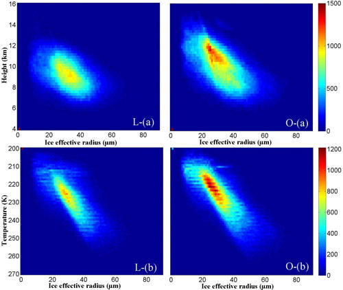
Fig. Occurrence frequency of IER changed with (a) heights and (b) temperatures over the land area (L-) and ocean area (O-).
This research is recently published in Journal of Climate, an international top atmospheric sciences journal.
Download: http://journals.ametsoc.org/doi/abs/10.1175/JCLI-D-14-00329.1
Citation: Huo, Juan and Daren Lu. 2014, Physical properties of high-level cloud over land and ocean from CloudSat/CALIPSO data. Journal of Climate, Vol. 27, No. 23. 8966-8978.
Key words: Cirrus clouds, Cloud microphysics, Satellite observations, Climate models, Cloud parameterizations, Clouds
Contact: Dr. HUO Juan, huojuan@mail.iap.ac.cn
