The metropolis of Beijing is the political, economic and cultural center of China, and continues to be rapidly urbanized. Many important activities are held there, and so accurate meteorological prediction is an urgent necessity. For instance, in 2015, particular attention was focused on the weather systems during early September because a formal parade was due to take place in Beijing’s Tiananmen Square on 3 September 2015. Fortunately, the weather was fine that day because a deep downdraft associated with an upper-level ridge predominated over Beijing. However, just one day later, on 4 September, strong rainfall occurred suddenly (Figure 1).
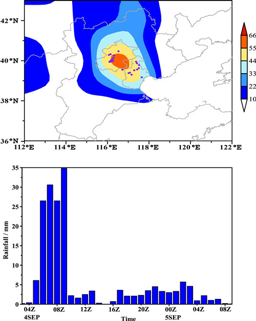
Figure 1. (a) Precipitation amounts recorded by automatic weather stations from 0000 UTC 4 to 0000 UTC 5 September 2015 (units: mm). Precipitation amounts larger than 10 mm are shaded and the purple dots represent amounts larger than 100 mm. (b) Hourly precipitation amounts at Xiangshan, Beijing (units: mm). (Zhao et al., 2016)
As is well known, Beijing is located in the Asian monsoon region. As such, heavy rainfall occurs frequently during the summer monsoon season, and cold snaps accompanied by snow sometimes occur during the winter monsoon season. Between these two seasons, autumn is a transitional period during which flat westerlies with short waves related with weak and cold air move along the midlatitude zone, and the weather in Beijing changes very quickly. After mid-August, strong rainfall decreases gradually, with just the occasional occurrence of light rain. Typically, it is clear and warm in Beijing during autumn, a period referred to as “Qiu Gao Qi Shang” in Chinese (“clear and crisp autumn air”). Whilst much previous research has been conducted regarding extreme weather events during summer and winter, only a few autumn cases in Beijing have been investigated thus far. This knowledge gap is addressed in a paper recently published in Atmospheric and Oceanic Science Letters (Zhao et al., 2016).
From 0100 UTC 4 to 0900 UTC 5 September 2015, average precipitation amounts of 55.3 mm and 67.7 mm were reported in the Beijing area including suburb and downtown area only, respectively (Figure 1). The accumulated precipitation amounts from 26 stations were larger than 100 mm, with the largest being 179.5 mm in Xiangshan, Beijing. This level of precipitation is unusual in Beijing in autumn, which begs the question: why did the weather change so quickly from 3 to 4 September?
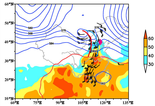
Figure 2. Geopotential height at 500 hPa (units: dagpm) and wind speeds greater than 8 m s−1 at 850 hPa (full bar: 4 m s−1), 0000 UTC 4 September 2015. The red and blue bold lines are trough lines at 700 hPa and 500 hPa, respectively. Shaded areas represent perceptible water greater than 30 mm d−1 (units: mm). The rrhomboid symbol represents Beijing. (Zhao et al., 2016)
The research results indicated that various factors (Figure 2), including stationary westerlies disturbances, a forward-titling trough, warm shear line, unstable stratification and convective available potential energy release, a low-level jet, and a series of mesoscale convective systems, caused the unusual rainfall event on 4 September. Therefore, it is reasonable that extreme weather events can also occur, on occasion, in Beijing during autumn.
The authors revealed that autumn heavy rainfall in Beijing can occur as long as favorable environmental and triggering conditions exist. Of relevance is the special situation in East Asia, part of the largest continent of the world, involving the Tibetan Plateau being located in West China and the Pacific Ocean to the east of China. This geography means that the weather systems at play are highly complicated and quite different from those found in other areas. Indeed, the heavy rainfall on 4 September 2015 in Beijing was quite different to that typically caused by extratropical cyclones and fronts in Europe and North America, as well as the rainfall associated with band-shaped Mei-yu fronts in East Asia. Local and sudden characteristics, rather than those of a systemic nature, are particularly obvious. The unusual rainfall in Beijing was caused mainly by the interaction between middle and lower latitude systems. They were, respectively, the dry and cold air associated with the short wave trough from the north, and the moist and warm air related with the low-level jet from the South China Sea. The former provided the dynamical lifting and triggering, the latter transported abundant moisture to Beijing, and both were highly conducive to the formation of clouds and precipitation in Beijing.
Whilst clearly an important step towards a better understanding of uncommon autumn rainfall in this part of the world, further research is still needed. For instance, precisely when, where and how can different systems interact with each other? This is just one key scientific problem requiring investigation to improve the prediction accuracy of this type of rainfall.
Reference
Zhao, S.-X., J.-H. Sun, and R. Lu. 2016. “Analysis of '9.4'unusual rainfall in Beijing during autumn 2015.” Atmospheric and Oceanic Science Letters 9(3). doi:10.1080/16742834.2016.1162083.
Contact: Prof. Sun Jianhua, sjh@mail.iap.ac.cn
