The Interdecadal Pacific Oscillation (IPO) and Atlantic Multidecadal Oscillation (AMO) are the leading modes of decadal and interdecadal climate variability in the Pacific and Atlantic Ocean, respectively. Previous studies suggest that the phase transition of the two modes could cause the changes of the general circulation in the whole Northern Hemisphere.
North China and the Southwest US are typical arid and semiarid regions, often hard hit by serious droughts. Many studies have attributed their interdecadal precipitation variability to the IPO or AMO, respectively. For example, the warm IPO phase corresponds to below-normal precipitation over North China but above-normal precipitation over the Southwest US, implying an obvious out-of-phase relationship for precipitation regime shift.
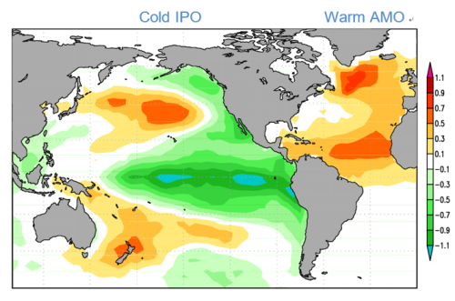
The distribution of Sea Surface Temperature anomalies associated to the cold IPO and warm AMO phases. (Image by YANG Qing)
"Although many studies have investigated the contrasting relationship of precipitation variability between Asia and North America, the circulation mechanism for the seesaw relationship remains unclear", said the first author, Dr. YANG Qing, working with Prof. MA Zhuguo in the Institute of Atmospheric Physics (IAP), Chinese Academy of Sciences.
Using data from observations, reanalysis, and a set of AGCMs simulations, they found the seesaw could be mainly driven by the IPO, while the AMO contributes oppositely and less. Modulation of precipitation by the IPO tends to be intensified when the AMO is in the opposite phase, but weakened when the AMO is in the same phase.
"The large-scale circulation anomaly occupying the entire northern North Pacific is the direct cause of the seesaw." said Dr. YANG. The warm IPO phase is associated with an anomalous cyclone over the northern North Pacific; consequently, anomalous southwesterly winds bring more moisture and rainfall to the Southwest US, while northwesterly wind anomalies prevail over North China with negative rainfall anomalies. The seesaw of rainfall anomalies reverses sign when the circulation anomaly becomes anticyclonic during the cold IPO phase.
Their study entitled "Interdecadal Seesaw of Precipitation Variability between North China and the Southwest United States" was published online in Journal of Climate on 15 may, 2019.
Reference:
Yang, Q., Z. Ma, P. Wu, N. P. Klingaman, and L. Zhang, 2019: Interdecadal Seesaw of Precipitation Variability between North China and the Southwest United States. Journal of Climate, 32, 2951-2968. https://journals.ametsoc.org/doi/full/10.1175/JCLI-D-18-0082.1
Media contact: Ms. LIN Zheng, jennylin@mai.iap.ac.cn
