1997/1998 and 2015/2016 El Nino episodes are regarded as two super El Nino events on record and have exerted profound influence on eastern China summer rainfall, as expected. However, on the sub-seasonal time scale, summer rainfall in these two years shows dramatic diversity, although the characteristics of the two super El Nino are similar.
For instance, the rainfall increases over central China (approximately 30°N, 35°N) and decreases over southeastern China (approximately south of 25°N) in August 1998. On the contrary, in the same month in 2016, the rainfall decreases over central China and increases over southeastern China(Figure 1a and 1b). This raises a scientific question: why is the August precipitation anomaly over eastern China reverse under two similar super El Nino conditions?
Based on the observational and model simulated analysis, PhD student SHEN Haibo (Nanjing University of Information Science & Technology, NUIST) together with Dr. HE Shengping (from Institute of Atmospheric Physics, Chinese Academy of Sciences and Geophysical Institute, University of Bergen) and Prof. WANG Huijun (NUIST) identified a close connection between the summer sea ice variability over Barents-Kara Seas and the August precipitation anomaly over eastern China (Figure 1c). The sea ice area anomaly over the Barents-Kara Seas induces a Rossby wave propagating eastward to East Asia, which causes positive barotropic and baroclinic energy convection near the exit of the Asian jet stream. The accumulation of perturbation energy in East Asia stimulates the formation of the Pacific-Japan teleconnection, which is favorable for the dipole rainfall anomaly pattern over eastern China.
Thus, the positive and negative sea ice area anomaly over the Barents-Kara Seas in 1998 and 2016 may contribute the reverse August precipitation anomaly in eastern China.
The study was published in Journal of Climate.
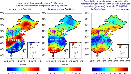
Figure 1 Distribution of August precipitation anomalies (units: mm/day) in China east of 105°E during 1998 (a) and 2016 (b); (c) Correlation maps of the August precipitation anomaly with regard to the July sea ice area index during 1979–2016 (the index is inverted; i.e., the negative correlation coefficients correspond to precipitation anomalies associated with anomalously low sea ice area). Dotted regions indicate that the values are significant at the 90% confidence level, based on the Student’s t test. (Shen et al., 2019)
Reference:
Shen, H., S. He, and H. Wang, 2019: Effect of Summer Arctic Sea Ice on the Reverse August Precipitation Anomaly in Eastern China between 1998 and 2016. J. Climate, 32, 3389–3407, https://doi.org/10.1175/JCLI-D-17-0615.1
Media Contact: Ms. LIN Zheng, jennylin@mail.iap.ac.cn
